Sometimes a new technology can lead to a step change in a well-studied scientific field. This is exactly what is currently happening in forest ecology. Forests are an essential part of the global carbon cycle, but they are complex environments and it is hard to accurately map their 3D structure. Enter our promising new(ish[1]) technology: terrestrial laser scanning (TLS). TLS can map out the 3D structure of trees in incredible detail, which could allow us to answer ecological questions that have been bugging scientists since before I was born!

This is the subject of a new Royal Society special issue – you can check it out here. I was involved in the first paper of this special issue, ‘New perspectives on the ecology of tree structure and tree communities through terrestrial laser scanning’, which is a review and a great starting point if this sounds like your kind of thing.
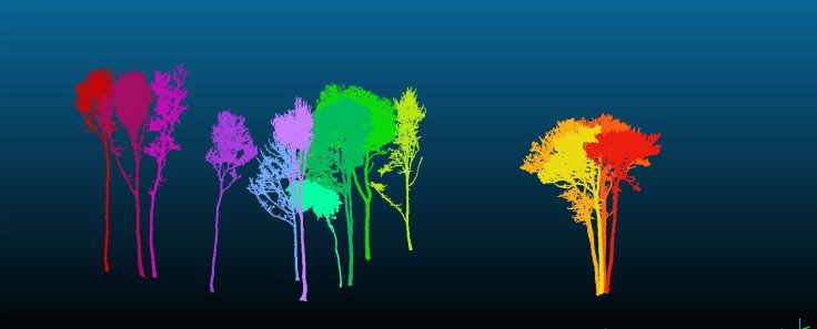
Previously, researchers measured the diameter, and sometimes the height, of trees in forest plots around the world. This led to big data sets about the diameter of trees and how they change over time, which have been very useful. But trees with the same diameter can have hugely different structures, which is important for the functioning of the forest. For example, trees in Northern Borneo (where these pictures were taken) are extremely tall for their diameter leading to a very high concentration of Carbon stored per hectare.

I have spent just over two months taking laser scans in forests. It is slow work and sometimes frustrating, but the results are great. The scanner is basically a high-tech laser rangefinder. We put it on a tripod in the forest and it rotates very slowly, measuring the distance to millions of points in the forest. This takes about five minutes, during which time we sit on the ground and relax, trying not to get in the way. Then, we move it 10m and start again. For a 1ha plot that adds up to 121 locations. Each position needs to be scanned in both the upright and horizontal positions, meaning 242 scans. Oh, and you can’t scan if its windy or rainy! Here is a link to a nice video made by some specialists that I am collaborating with, which that explains the basics nicely. https://www.youtube.com/watch?v=wANRdliE1zQ.
Our review article demonstrates some of the potential uses of TLS in forest ecology, which stem from the ability to map tree architecture. We outline the ways TLS could help explain:
- How a tree distributes water and other resources around its branching network, which has implications for competition between trees of different species and environments.
- How the size and shape of the tree affect the way it moves in the wind, which determines how likely it is to snap or uproot.
- Whether different architectures may aid seed dispersal.
This is just one example of the ways technology is changing ecology. This is going on all the time. Even in this same special issue journal one paper uses the TLS data to test whether they can use drones to map forests – and therefore cover a much larger area for a fraction of the cost. I hope that, as this field progresses, these innovative uses of technology will continue to help us answer these important questions both faster as well as more accurately.

[1] Support for data collection underpinning this figure is acknowledged from: Metrology for Earth Observation and Climate project (MetEOC-2), grant number ENV55 within the European Metrology Research Programme (EMRP). The EMRP is jointly funded by the EMRP participating countries within EURAMET and the European Union; NPL; the NERC National Centre for Earth Observation (NCEO) and UCL
[2] In reality this technology has been around for quite a while. What is new here is that it is being used in forests. Even more important and novel are the software tools that have recently been developed to help use use TLS data from forests, without which we would be completely stuck.
